Wiki FP7-Tiramisu


Published on Wiki FP7-Tiramisu (http://geospatial.fp7-tiramisu.eu)

System establishment, capacity building and training for RPAS survey in Mine Action (RPAS-MA-DEPLOY)

General info
Category: 
System establishment - capacity building and training for RPAS survey
Platforms: 
Multi-rotor RPAS

Technical details

Required processing: 
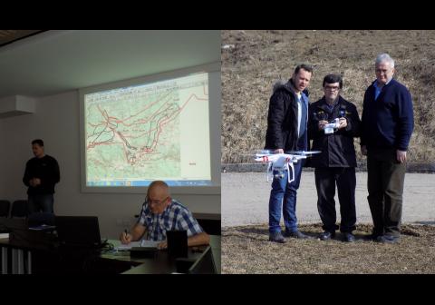
Training surveyors in domain of: - analytical preparation of data for survey by RPAS; - defining object oriented survey requirements (regarding object detection, classification, recognition and identification); - mission planning including security issues; data processing; - implementation survey results in existing MIS; - flight training (starting on simulator).
Data requirements: 

MAC's statement of needs regarding existing survey technology.

Validation process: 

Yes/ Validated through successful, operational project in Bosnia and Herzegovina/ 2014-2015.

External information: 
Impact of Flooding on Mine Action in Bosnia and Herzegovina, Croatia, Serbia.
Mine action after the floods regional synergy in emergency response, technology development and capacity building.

Description

System establishment, capacity building and training of deminers-surveyors.

Why using remote sensors?: 

Although RPAS are potentially very useful in NTS for areas where necessary information cannot be collected using standard MA technologies and procedures, this technology was never used and tested in NTS operations before its implementation in the project with BHMAC in 2014.
Experience from this implementation shows that the application of RPAS technology to Mine Action NTS must include capacity building and training for the deminers-surveyors, in addition to the establishment of the technical system.

Contacts

Technical contact: 
CTDT
[email protected]
Operational contact: 
CTDT
[email protected]
Source URL (modified on 09/22/2015 - 22:20): http://geospatial.fp7-tiramisu.eu/products/system-establishment-capacity-building-and-training-rpas-survey-mine-action-rpas-ma-deploy