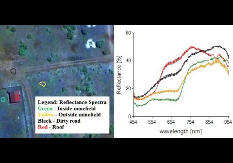
Required processing:
Mission planning, survey, data calibration, hyperspectral imagery analysis.
Data requirements:
Helicopter and/or RPAS, hyperspectral sensor, appropriate weather and vegetation conditions, permission by national authorities, HS imagery, navigation data of the platform.
Validation process:
Under way/ operational/ CROMAC, end of 2015.
Hyperspectral airborne survey for providing scene discrimination maps and maps of vegetated area contaminated by land mines.
Why using remote sensors?:
Hyperspectral airborne Non-Technical Survey provides a rich insight of the scene.
It makes it possible to discriminate minefields in an SHA, which was impossible up to now. It also permits the discrimination of vegetated areas contaminated by landmines.
Technical contact:
Operational contact:

