Wiki FP7-Tiramisu


Published on Wiki FP7-Tiramisu (http://geospatial.fp7-tiramisu.eu)

Bomb craters

General info
Category: 
Detection of specific objects
Platforms: 
Very High spatial resolution satellite
Scale: 
1/25 000 to 1/1 500
Spatial resolution: 
10 to 0.5m
Sensor reference: 
QuickBird-2
IKONOS-2
Pleaides1A
Pleiades1B
WorldView-2

Technical details

Required processing: 
Orthorectification and georeferencing of the aerial photographs, application of the detection algorithm.
Data requirements: 
Very-high resolution satellite images (e.g. Pleiades, QuickBird, WoldView-2, IKONOS, etc.).

Description

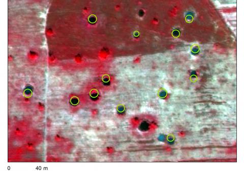
Georeferenced polygons (circles) outlining the bomb craters.

Why using remote sensors?: 

On satellite images, bomb craters filled with water produce contrasted discs that may be detected either visually or automatically. Comparing bomb craters detected on images with historical bombing data can help locate UXOs.

Contacts

Technical contact: 
Royal Military Academy
[email protected]
For more information

V. Lacroix and S. Vanhuysse, Crater Detection using CGC - A New Circle Detection Method, ICPRAM 2015.

Source URL (modified on 10/13/2015 - 02:00): http://geospatial.fp7-tiramisu.eu/products/bomb-craters